 Umvoti Municipality Your Place of Peace & Prosperity
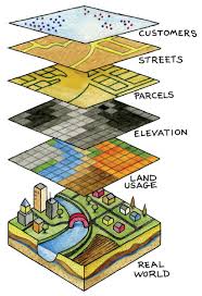
Spatial analysis is how we understand our Municipal Area — mapping where things are, how they relate, what it all means, and what actions to take to improve facilities to our communities.
From computational analysis of geographic patterns to finding optimum routes, site selection, and advanced predictive modeling, spatial analysis is at the very heart of geographic information system (GIS) technology.